

On November 17th, 2020, Project Manager Brian Creamer, AICP, SITES AP presented at the Northeast ARC (NEARC) Users Group Fall Virtual Conference on Improving Efficiencies in Asset Inventories with Survey123 and Feature Reports. The presentation utilized a MassDOT signage inventory case study to demonstrate how Survey123 and ArcGIS Online can be used to efficiently gather, store, and access this data, allowing communities and agencies to seamlessly apply this information to future projects.
MassDOT maintains signage inventories for its roadways, including all Guide, Regulatory, and Warning sign conditions. Sign and asset inventories are a practice every Department of Transportation regularly undertakes to develop their maintenance and improvement programs, and Massachusetts replaces thousands of signs along highways and roads each year. With each sign having its own individual location, these replacements require a robust, systematic approach to ensure an organized replacement strategy.
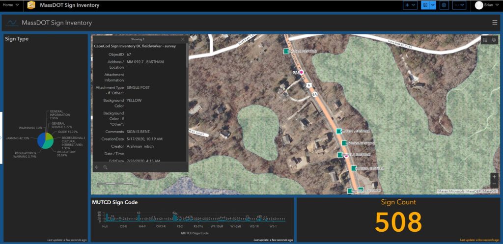
In the past, the sign inventory process has been lengthy and cumbersome, requiring site visits, photo documentation, and extensive data entry and mapping. As MassDOT’s consultant for a sign inventory of over 1,000 signs on Route 6 on the Lower Cape (from Orleans to Provincetown), Nitsch Engineering utilized ESRI Survey123 to collect sign data on a mobile tablet, automatically link photographs of the signs with the unique sign identification system, geo-locate each sign, and evaluate the retro-reflectivity of each sign according to Federal Highway guidance (FHWA-SA-07-020). These 1,000 sign records were then exported using the Survey123 Feature Report tool into a customized report which includes reference records, photographs, and a geopoint over ArcGIS Online basemap layers in context with other inventoried signs and mile markers.
With a focus on the browser-based experience of Survey123, Brian showcased the process of implementing the Survey123 Feature Report tool to attendees. The presentation was followed by a live demonstration of linking an ArcGIS Online webmap to a Feature Report template, incorporating interaction from attendees for feedback regarding source location and base mapping information.